Logo

dev-resources.site

for different kinds of informations.

Create a 3D city model with GISBox!

Published at
1/14/2025
Categories
gis
gisbox
3d
3dmodel
Author
gisbox
Categories
4 categories in total
gis
open
gisbox
open
3d
open
3dmodel
open
Author
6 person written this
gisbox
open
Create a 3D city model with GISBox!

3D models are an essential tool in the fields of urban planning, architectural design and geographic information management. GISBox, as a free and powerful platform, allows users to quickly generate 3D models of cities. Below, we will introduce in detail the steps to generate a 3D model of a city using GISBox.

1: Create a new scene
The first step to generate a city 3D model in GISBox is to create a new scene.

Image description

2: Select from the map
Vector data is usually required for generating a city 3D model, and SHP files (Shapefiles) are one of the widely used formats.
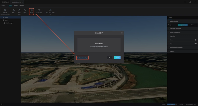
Image description
Find and click the "SHP" option on the scene editing screen.

The system will pop up a window and select the "Select from the map" mode.

Go to the city area you want to model and select the desired area.

This step allows you to accurately select the city range and provides important data for model generation.

3: Import data
In order to generate a 3D model, you need to further refine the selection and import data.
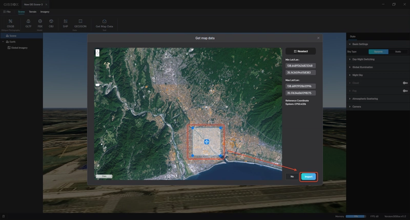
Image description
On the map screen, use the Rectangle tool or Custom Polygon tool to make a selection.

Once you are satisfied with the selection, click the Import button.

GISBox will automatically load the data of the selected area into the scene, preparing it for the next process.

With accurate selection and data import, the system will have the geographic information required to generate the city model.

4: Generate City 3D Model
After the data selection and import are complete, generate the 3D model:
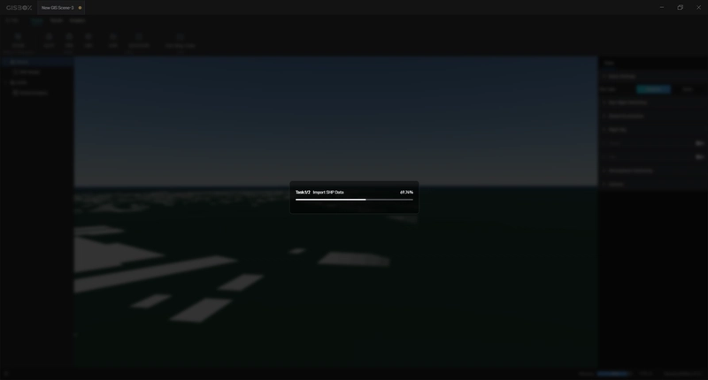
Image description
Find and click the Generate 3D Model option on the scene screen.

The system will generate a 3D model of the buildings and terrain based on the imported vector data and terrain information.

Once the model generation is complete, you can review and edit the model by dragging and zooming with the mouse.

You have now successfully created a city 3D model using GISBox, which can be further utilized for analysis, planning, or visualization purposes.
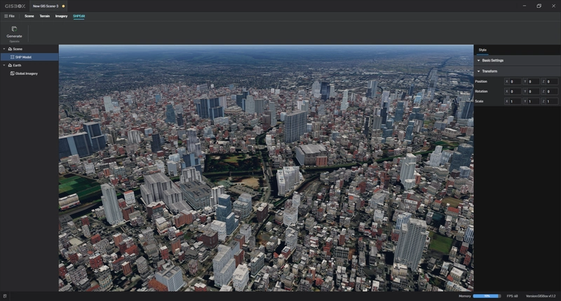
Image description
Summary
GISBox provides easy and efficient tools and processes to help you go from scene creation to city 3D model generation in just a few steps. The "select from map" feature, accurate data import and automatic model generation allow users to quickly obtain high-quality 3D city models.

3d Article's
30 articles in total
Favicon
3D models from images with local AI
Favicon
Create a 3D city model with GISBox!
Favicon
How to improve MSAA performance of MTKView
Favicon
GISBox makes GIS data circulation more convenient and efficient
Favicon
GISBox point cloud: steps to achieve efficient 3D data tiling
Favicon
Using GISBox to optimize 3D data conversion from OSGB to 3DTiles
Favicon
3D Digital Asset Management Solution Expands Autodesk File Format Support
Favicon
One-stop OSGB/3Dtiles editing, conversion and publishing tool
Favicon
A GIS tool for free editing, converting and publishing OSGB/3D Tiles
Favicon
GISBox vs QGIS: How to choose the best GIS tool?
Favicon
Transform Your Construction Process with BIM Model 3D
Favicon
Glasses-free 3D technology leads the new trend
Favicon
Level of Detail (LOD): A Cornerstone of Efficient 3D Modelling
Favicon
OSGB to 3DTiles: Using GISBox to achieve efficient 3D data conversion
Favicon
Free OSGB/3Dtiles editing and conversion publishing platform - GISBox
Favicon
echo3D Wins the 2024 CloudX Award for Cloud, Object & Data Storage
Favicon
Stop Sharing 3D Assets Over Email and Shared Drives & Start Using A 3D DAM
Favicon
One-Stop Solution: GISBox Simplifies OSGB to 3DTiles Conversion
Favicon
Five GIS editing tools to help you on your GIS journey
Favicon
Five Common 3D Modeling Mistakes and How to Avoid them.
Favicon
5 of the best Revit to 3DTiles tools
Favicon
From the Physical World to the Virtual City: The Future Role of GIS and 3D Technologies in Urban Planning
Favicon
Smart Transportation! GIS and 3D Scene Technology in Traffic Accident Analysis
Favicon
Top 5 Tools for Converting OSGB Files to 3DTiles: A Comprehensive Guide
Favicon
Top 5 GIS Toolboxes: Unlocking the Full Potential of Geographic Information Systems
Favicon
2D va 3D massivlar haqida C#(C-Sharp) tilida tushuncha
Favicon
3DtoMe - Pitch your 3D product, together
Favicon
Top 5 3D tools recommended: easily create your 3D creativity
Favicon
Wings Engine Powers Education: Revolutionizing Virtual Learning Environments
Favicon
Evolving 3D Furniture Trends in eCommerce

Featured ones: